

Description
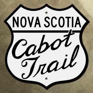
The Cabot Trail is a scenic route on Cape Breton Island, Nova Scotia. It forms a 300-km loop around the northern tip of the island. The route is named after the explorer John Cabot, who landed in the area in 1497. Back in the 1940s, the Cabot Trail was signed with a variation of the standard provincial trunk highway sign. Nova Scotia still uses a trunk highway sign in the same fundamental form into the present day. It resembles the national route shields of a certain large jurisdiction of some importance, located to the south.
Relieve your travels down this beautiful maritime route with our recreation of the Cabot Trail route marker. Every detail has been precisely replicated, from the fonts, to the layout, to the shape of the shield. Original signs like this are hard to find, and often command a hefty premium on the collector’s market. Avoid uncertainty and save money with our replica of this classic sign.
Our replica Cabot Trail route marker is printed on heavy 14-gauge steel. Its glossy, non-reflective finish is durable enough to be displayed indoors or outdoors. The sign in its original size is 14⅜ inches square, but we also offer it in sizes from 12 inches square, all the way up to 36 inches square. Each size includes two mounting holes for easy installation. Are you looking for a sign for another scenic byway, either in Nova Scotia or elsewhere? Or perhaps this sign in a later style? We can help! Just contact Jake to get started on your custom order.

Reviews
There are no reviews yet.